Improved information flow along inland waterways, also across intra-European borders, is intended to increase the efficiency of waterborne transportation and logistics throughout Europe. To implement these plans, thirteen countries have decided to jointly conduct the research project RIS COMEX (River Information Services COrridor Management EXecution).
As part of RIS COMEX, which is coordinated by the Austrian viadonau and runs over 4 years, the infrastructure of the existing AIS services will be expanded, and the Inland AIS Standard of the future will be defined to be able to transmit further data from ship to ship and land to ship.
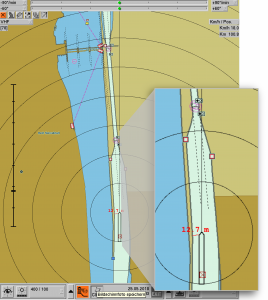
The additional AIS messages are intended to inform the helmsmen timely about current water levels, lock waiting times, bridge clearance or temporary construction work and any resulting impairments. Further, more AtoNs (AtoN = Aid to Navigation) shall be used in the future. AtoNs are real stationary traffic signs and tons, which are also shown in maps. Those traffic signs will obtain a sending transponder. Thus, a navigation system aboard the ship can display the real actual position and current state immediately and correct.
In addition, a nautical officer can set AtoNs temporarily and transmit their virtual position to the on-board computers of the vessels, in order to warn the skippers of shallows or an average from the traffic control center and to mark the safe route.
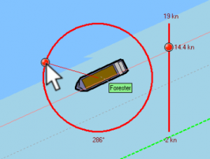
Dr. Thomas Gern, CEO of in-innovative navigation GmbH, reports: “Inland ECDIS chart display and Inland AIS transponder, both are mandatory equipment in commercial inland shipping for several years now. in-innovative navigation GmbH is one of the well-known companies that manufactures such integrated navigation systems, and we will investigate together, how the new information should be presented in a meaningful and reliable way on the board computer. At the same time, test corridors will be set up at various European waterways to expand the current AIS network. We are proud to report, that RIS COMEX has commissioned our company with the research work for the vessel equipment and also to provide the German AIS-infrastructure necessary on land. The new functions can be tested and presented along these river sections. On the basis of the results, the European RIS Expert Groups will be able to develop the new standard for inland AIS communication.”